Storm force Southerlies
17th December 2025
It was a particularly windy and dreich day in the Northern Cairngorms today with the brightest weather out to the North-East, with just fleeting glimpses of the sun through the Ryvoan Pass. It must have been much brighter in Nethy Bridge and of course in Findhorn on the Moray coast. The METAR information at RAF Lossiemouth supported the view that it was a very different day out at the coast:
1350Z Wind 190° 9kt. Visibility 10km or more. Clouds few 2100ft, scattered 4200ft, broken 20,000ft. Temperature 12°C, dew point 7°C. QNH 992hPa. No significant change.
It is always fun to decode this from the raw METAR code. But it is probably more pertinent to consider the data from the Cairngorms, with regular gusts at 84 mph and a maximum gust recorded of 99 mph on the summit of Cairn Gorm at 1245 metres. Frequently, gusts in Glenmore are often quite significant in Southerly winds as the air is compressed over the Cairngorm plateau producing down slope Föhn gusts. This was certainly the case today with a fully inflated windsock on the helipad at Glenmore Lodge, and a mild buffeting in the car park.
What was particularly notable overnight was the speed in which the freezing level rose above the summits. Some snow showers occurred overnight as expected, but the more persistent precipitation fell as rain at all levels rather than snow.
Correspondingly, there has been little change in the distribution of snow, although there is a dusting of snow anticipated for tomorrow. These amounts are not expected to be significant, but showery weather is difficult to predict and there is always the potential for more snow if showers were to merge. There is the potential for isolated windslab development around coire rims and gully tops. Any deposits will be unsupported with very firm old snow or bare ground below.
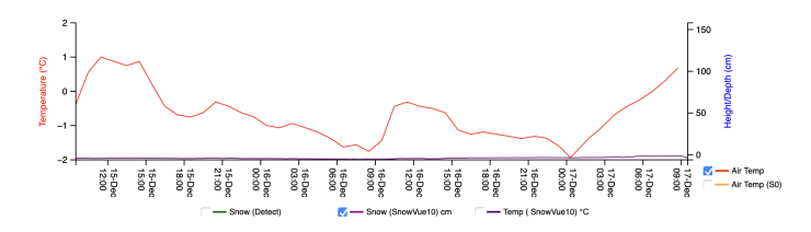
This is data from the SIMBA snow monitoring site in Coire Cas at approximately 1000 metres. The air temperature is plotted from the 15th December through to 0900 on the 17th December (today). Note the temperature of -2 at midnight followed by a gradual rise to above freezing at 0900. Most of the precipitation arrived after this time, resulting in rain at most levels. The snow height/depth is plotted in purple, essentially there is no snow at the site currently. Data with thanks to (c) SAMS Enterprise.
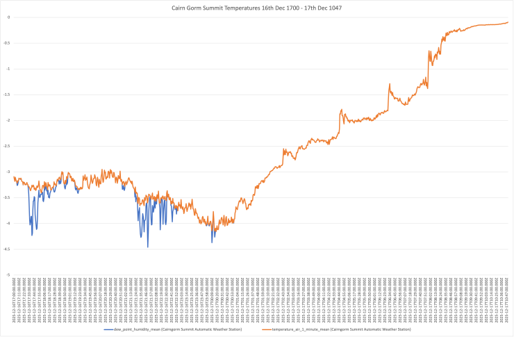
This plot shows the temperatures from the 16th December at 1700 through to the 17th December at 1047. On the bottom axis the times are listed along with Z = ZULU which is the designation for GMT. Blue = the dew point humidity mean i.e. representative of the Wet Bulb Temperature while Orange = the Air Temperature mean. The overnight temperatures were relatively low with periods when the humidity dropped resulting in showers falling as snow at lower elevations. However, temperatures soon rose, and at 1500 the temperature is showing as +2.3 Degrees Celsius. Inevitably, this has resulted in the thaw of superficial snow at all levels today. Finally the Met Office observation station viewer was suggesting that the data wasn’t reliable this morning, and it may have been warmer than the figures shown. As mentioned in previous blogs one theory is that measurements are sometimes frustrated by the presence of rime ice and water giving temperatures around the triple point 0.01 Degrees Celsius or 273.16 K. (c) Met Office.
Comments on this post
Got something to say? Leave a comment